Geography
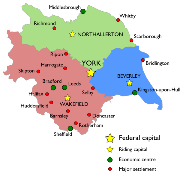
Yorkshire is divided into three Ridings and a Federal capital district. Each Riding has its own capital and one or more economic centres.
Contents
Map
Administrative divisions
City of York
York is our historic capital city, situated at the centre of all three ridings. It is administered directly by the federal government.
North Riding
The North Riding is historically the agricultural heartland of Yorkshire, and is home to some of the most beautiful scenery, including the Dales and the North Moors.
Its northern border is the River Tees, which forms the boundary between Yorkshire and our neighbour Northumbria. To the west the border is the River Lune, with the Northwest Confederation on the other side.
Major settlements include:
- Capital: Northallerton
- Economic centre: Middlesbrough
- Malton
- Richmond
- Scarborough
- Whitby
East Riding
The East Riding is the smallest Riding and it has a complex past. It has historically been home to Yorkshire's maritime industry.
Its southern border is the Humber, which forms part of the border between Yorkshire and England to the south.
Major settlements include:
- Capital: Beverley
- Economic centre: Kingston-upon-Hull
- Bridlington
- Goole
West Riding
The West Riding is the most populous Riding, owing to its industrial past.
Its border to the west and south is the Pennine mountain range, which it shares with the Northwest Confederation and England.
Major settlements include:
